Destructive tornadoes ripped through parts of Illinois and Indiana late Tuesday, killing an elderly couple in Lake Village, Indiana, and causing widespread damage to homes and businesses. The storms, part of a multi-day severe weather outbreak, also brought grapefruit-sized hail and knocked out power to thousands across the Midwest.
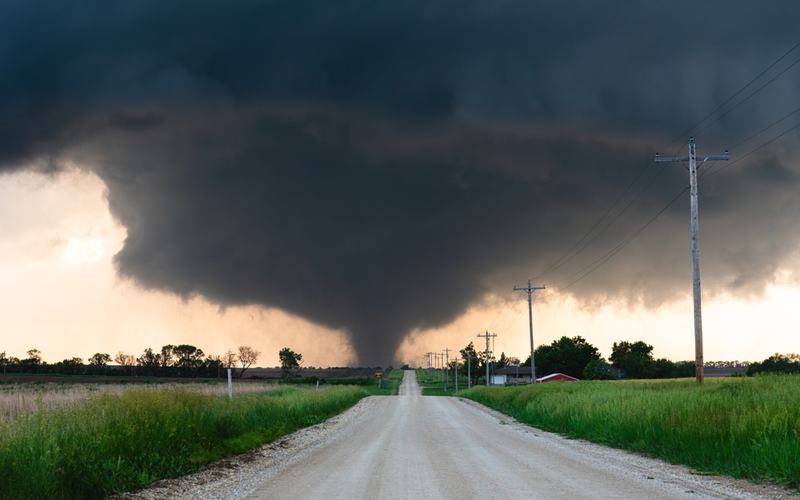
A supercell thunderstorm tracked more than 120 miles over nearly 4.5 hours from northeast Illinois into northern Indiana, spawning at least four tornadoes. Hardest hit were Kankakee County in Illinois and areas around Lake Village and Wheatfield in Indiana. In Kankakee, multiple buildings were torn apart, roofs were ripped from homes, and streets were littered with debris and downed power lines. The National Weather Service activated its Emergency Operations Center for damage assessments and search-and-rescue efforts.
In Lake Village, first responders described the scene as total devastation, with collapsed houses and a destroyed Family Dollar store where two employees were rescued uninjured after being trapped inside. Newton County Sheriff Shannon Cothran urged residents to stay away, noting significant home damage but describing reported injuries as minor so far. Lake Township Fire Department Chief Rob Churchill called it a long night ahead for recovery teams.
Hail up to 6 inches in diameter fell near Kankakee, potentially setting an Illinois record pending verification, while 3-to-5-inch stones pelted Chicago's southwest suburbs. Confirmed tornadoes also touched down in Iowa, Oklahoma, and Texas, though surveys continue to determine their strengths, with possible EF3 or higher ratings in Illinois and Indiana.
This outbreak follows a deadly weekend event from March 5-7 that killed eight people across the Plains and Midwest. Tuesday's storms affected tens of millions under tornado watches and warnings, with eight tornado reports in northern Illinois and Indiana alone.
As of Wednesday afternoon, the severe weather threat has shifted eastward. The Storm Prediction Center outlined a slight risk of severe thunderstorms from the lower Mississippi Valley through the Ohio Valley and Mid-Atlantic, with damaging winds as the primary concern and isolated tornadoes possible. Active tornado watches cover parts of Indiana, Kentucky, Ohio, and further east into Pennsylvania and Virginia. Heavy rain risks flash flooding in already saturated areas.
Emergency officials continue damage surveys, and residents in affected areas are advised to avoid downed lines and report hazards to authorities.

Comments
No comments yet. Be the first to share your thoughts.