
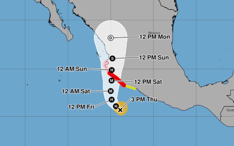
Tropical Storm Simon is forecast to strengthen into a Category 4 hurricane before reaching Mexico’s Pacific coast, prompting hurricane warnings across parts of Michoacan, Colima and Jalisco. The National Hurricane Center warned that the storm could bring life-threatening winds, storm surge, flash flooding and mudslides as it approaches land.
As of 3 p.m. Central Standard Time Thursday, Simon had maximum sustained winds of 70 mph and was located approximately 230 miles south of Manzanillo, Mexico. The storm was moving west at 6 mph, with tropical-storm-force winds extending up to 70 miles from its center.
The National Hurricane Center forecast Simon to become a hurricane Thursday night before turning northwestward early Friday and moving northward Friday night. The storm’s center was expected to reach the southwestern or west-central Mexican coast Saturday afternoon or evening, with forecast winds potentially reaching 130 mph by early Saturday.
Satellite imagery showed signs of an emerging eye, while low wind shear, abundant atmospheric moisture and exceptionally warm ocean waters were expected to support rapid intensification. One forecast model cited by the hurricane center placed the probability of rapid intensification over the following 24 hours above 70%.
Forecasters cautioned that models differed on the storm’s precise track and the timing of its turn toward the coast. Those differences could affect which communities experience the strongest winds and heaviest rainfall.
Mexico issued a hurricane warning stretching from Punta San Telmo to Playa Perula, covering portions of Michoacan, Colima and Jalisco. A hurricane watch extended westward from Playa Perula to Punta Mita, including parts of Jalisco and Nayarit. A tropical storm watch also covered the Michoacan coastline between Punta San Telmo and Lazaro Cardenas.
Hurricane conditions were forecast to begin in the warning area Saturday afternoon or evening, while tropical-storm conditions could arrive Saturday morning. Tropical-storm conditions were possible in the watch area beginning Friday, with hurricane conditions potentially developing there by Saturday night.
The National Hurricane Center urged residents to complete preparations to protect lives and property by late Friday, warning that additional watches or warnings could be issued as the forecast becomes clearer.
Heavy rainfall poses another major threat. Simon was expected to deliver 8 to 15 inches of rain across parts of southwestern Mexico through Sunday, with isolated totals of 15 to 25 inches possible in portions of Michoacan, Colima and Jalisco. The rainfall could trigger dangerous flash flooding and mudslides, particularly in mountainous areas.
Dangerous storm surge was also possible along the immediate coastline near and east of the storm’s eventual landfall location. Forecasters warned that large, destructive waves could accompany the surge, while swells spreading along Mexico’s southwestern and west-central coast were expected to produce hazardous surf and life-threatening rip currents through the weekend.
Residents in the affected areas were urged to monitor official forecasts and follow instructions from local authorities as Simon approaches the coast.

Comments
No comments yet. Be the first to share your thoughts.