
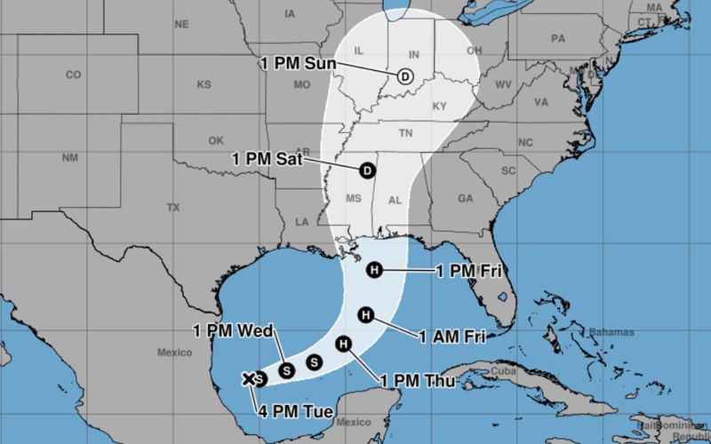
Tropical Storm Isaias formed early Wednesday over the warm waters off eastern Mexico, prompting Gulf Coast residents to prepare for the possibility of dangerous winds, heavy rain, and storm surge.
The storm was centered about 285 miles west of Progreso, Mexico, and roughly 580 miles southwest of the mouth of the Mississippi River, according to the National Hurricane Center. Isaias had maximum sustained winds of 40 mph and was moving east-northeast at 8 mph.
Forecasters expected the storm to strengthen as it moved toward the Gulf Coast, potentially becoming the first hurricane of the Atlantic season.
The exact location of landfall remained uncertain, but early projections indicated that the center of the storm could reach the coast late Friday or early Saturday somewhere between eastern Louisiana and the western Florida Panhandle.
The National Hurricane Center warned of an increasing risk of dangerous wind and storm surge impacts along portions of the northern Gulf Coast and urged residents from Louisiana through the Florida Panhandle to monitor updated forecasts and make sure their hurricane preparations were in place.
Florida Gov. Ron DeSantis declared a state of emergency for 25 counties across the Panhandle and Big Bend regions. The declaration activates the state's emergency management plan and allows state officials to deploy personnel and equipment as needed.
Isaias was also expected to produce periods of heavy rainfall across parts of the Gulf Coast and much of the Southeast beginning Friday and continuing through the weekend.
The storm is developing during an unusually quiet Atlantic hurricane season. Forecasters have attributed the reduced activity in part to a strong El Niño, which can disrupt hurricane formation in the Atlantic, while storm activity in the Pacific has remained above average.

Comments
No comments yet. Be the first to share your thoughts.